Cold fronts, showers, land - sea contrasts
June 5, 1999 08:15 UTC
A cold front (1) has just passed over the North-West of France. Behind it, the sky is clear. The shade from the cloudy strip appears on the visible image. A secondary cold front (2) approaches Brittany. Thermal contrast is more significant: there are many shower clouds (3) behind this secondary front. The sea (4) is not easily distinguishable from the land (5) on the infrared image: their respective temperatures should be nearly the same. On the other hand, on the visible image, the sea (4) is much darker than the land (5), because it does not reflect the solar radiation as the land does.
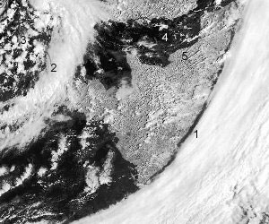
Visible image

Infrared image