METAR-TAF
Airports :
Alpine
Alice
Alpine
Austin–Bergstrom
Austin-Camp Mabry
Austin-Executive
Brownsville
Brownwood
Burnet
Chihuahua
Ciudad Juárez
Ciudad Victoria
Coleman
Comanche
Corpus Christi
Corpus Christi / Kingsville
Cotulla
Culiacán
Del Rio
Del Rio
Dryden
Durango
Edinburg
El Paso
Falfurrias
Fort Bliss
Fort Hood / Killeen
Fort Hood / Killeen
Fort Stockton
Fredericksburg
Gatesville
Georgetown
Hamilton
Harlingen
Hebbronville
Hondo
Junction
Kerrville
Killeen
Kingsville
Laredo
Llano
Los Mochis
Marfa
Matamoros
Mazatlán
McAllen
Midland Intl.
Monclova
Monterrey
Monterrey Del Norte
New Braunfels
Nuevo Laredo
Odessa
Pecos
Piedras Negras
Pine Springs
Port Isabel
Reynosa
Robstown
Rockport
Rocksprings
Saltillo
San Angelo
San Antonio
San Antonio
San Antonio
San Luis Potosí
San Marcos
Sonora
Tampico
Temple
Torreón
Universal City
Uvalde
Waco
Waco
Waco
Weslaco
Wink
Zacatecas
Mexico, Northeast
Arizona
Mexico
Mexico, East
Mexico, Northwest
Mexico, Southwest
New Mexico
Texas, East
Texas, South
Texas, West
Alpine–Casparis Municipal Airport Alpine, Texas, United States
latitude: 30-23-03N, longitude: 103-41-00W, elevation: 1376 m
Current weather observation The report was made 24 minutes ago, at 13:35 UTC
Wind 6 kt from the South/Southwest
Temperature 22 °C
Humidity 38 %
Pressure 1015 hPa
Visibility: 16.1 km
Clear sky
METAR: KE38 181335Z AUTO 21006KT 10SM CLR 22/07 A2996 RMK AO2 T02220066
Time: 08:59 (13:59 UTC) TAF: missing
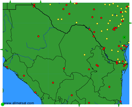
Weather observations and forecasts of more than 4000 airports (METAR and TAF reports).
The available stations are represented by yellow and red dots on the map.
Hover mouse over dot to see the name of the station.
Then click to see weather observations and forecasts.
To change the map : click on the green buttons with a black cross to zoom in, on the green button with a dash to zoom out, or on the green arrows for adjacent maps.