METAR-TAF
Airports :
Guernsey
A12-cpp
Aberdeen
Albert
Alderney
Barkston Heath
Beauvais
Belfast
Belfast City
Benbecula
Benson
Birmingham
Blackpool
Boscombe Down
Boulmer
Bournemouth
Brighton
Bristol
Brize Norton
Caen
Calais
Cambridge
Campbeltown
Cardiff
Carlisle
Cherbourg
Chièvres
Coningsby
Cork
Cranfield
Cranwell
Culdrose
D15-fa-1
Deauville
Derry
Doncaster Sheffield
Donegal
Dublin
Dublin
Dundee
East Midlands
Edinburgh
Ekofisk
Euro
Évreux
Exeter
Fairford
Farnborough
Glasgow
Glasgow-Prestwick
Gloucester
Goeree Le
Guernsey
Hawarden
Heimdal
Holbeach
Humberside
Inverness
Islay
Isle of Man
Isles of Scilly
J6-a
Jersey
K13-a
K14-fa-1c
Killarney
Kinloss
Kirkwall
Knock
Koksijde
Lakenheath
Land's End
Leconfield
Leeds Bradford
Leeming
Le Havre
Le Touquet
Leuchars
Lille
Linton-on-Ouse
Liverpool
London Biggin Hill
London-City
London-Gatwick
London-Heathrow
London-Luton
London-Southend
London-Stansted
Lossiemouth
Lydd
Manchester
Marham
Middle Wallop
Mildenhall
Newcastle upon Tyne
Newquay Cornwall
Northolt
Norwich
Oban
Odiham
Oseberg
Ostend
Oxford
P11-b
Paris-Charles De Gaulle
Pembrey
Pontoise
Preston
Rouen
Scampton
Scatsta
Shannon
Shawbury
Sleipner
Sligo
Southampton
Spadeadam
St Athan
Stornoway
Sumburgh
Tain
Teesside
Tiree
Topcliffe
Troll A
Troll C
Ula
Valley
Vlissingen
Waddington
Waterford
Wattisham
Wick
Wittering
Woodvale
Yeovilton
United Kingdom - Ireland
Belgium
Denmark
England
Europe
Faroe Islands
France
Germany
Ireland
Luxembourg
Netherlands
North Atlantic
North Sea
Scandinavia, Southwest
Scotland
Shetland
Spain
Wales
Guernsey Airport Guernsey,
latitude: 49-26N, longitude: 002-36W, elevation: 102 m
Current weather observation The report was made 36 minutes ago, at 11:20 UTC
Wind 5 kt from the South , varying between South/Southeast and South/Southwest
Temperature 15 °C
Humidity 67 %
Pressure 999 hPa
Visibility 10 km or more
Few clouds at a height of 2000 ft Broken clouds at a height of 4800 ft
METAR: EGJB 221120Z 18005KT 150V210 9999 FEW020 BKN048 15/09 Q0999
Time: 12:56 (11:56 UTC) Forecast The report was made 1 hour and 1 minutes ago, at 10:55 UTC
Forecast valid from 22 at 12 UTC to 22 at 21 UTC
Wind 5 kt from the Southwest
Visibility 10 km or more
Few clouds at a height of 1600 ft Scattered clouds at a height of 4500 ft
Becoming from 22 at 14 UTC to 22 at 16 UTC
Wind 15 kt from the South/Southeast
Broken clouds at a height of 1500 ft
Becoming from 22 at 16 UTC to 22 at 18 UTC
Wind 22 kt from the Southeast with gusts up to 35 kt
Visibility: 7000 m
Few clouds at a height of 1000 ft Broken clouds at a height of 1500 ft
light rain
Temporary from 22 at 16 UTC to 22 at 21 UTC
Visibility: 4000 m
Broken clouds at a height of 500 ft
rain
Probability 30% :
Temporary from 22 at 18 UTC to 22 at 21 UTC
Visibility: 1500 m
Broken clouds at a height of 300 ft
rain, drizzle
Becoming from 22 at 19 UTC to 22 at 21 UTC
Wind 27 kt from the Southwest with gusts up to 40 kt
Visibility 10 km or more
Scattered clouds at a height of 2200 ft
TAF: EGJB 221055Z 2212/2221 22005KT 9999 FEW016 SCT045 BECMG 2214/2216 16015KT BKN015 BECMG 2216/2218 13022G35KT 7000 -RA FEW010 BKN015 TEMPO 2216/2221 4000 RA BKN005 PROB30 TEMPO 2218/2221 1500 RADZ BKN003 BECMG 2219/2221 23027G40KT 9999 NSW SCT022
Weather observations and forecasts of more than 4000 airports (METAR and TAF reports).
The available stations are represented by yellow and red dots on the map.
Hover mouse over dot to see the name of the station.
Then click to see weather observations and forecasts.
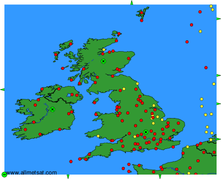
To change the map : click on the green buttons with a black cross to zoom in, on the green button with a dash to zoom out, or on the green arrows for adjacent maps.