Oil slicks
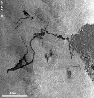
Oil from the wrecked tanker Prestige off the northwest coast of Spain had already reached the Spanish coast when ESA's Envisat satellite acquired this radar image of the oil slick, stretching more than 150 km. The image was captured by the Advanced Synthetic Aperture Radar (ASAR). The presence of oil on the sea surface damps down smaller wind generated waves. It is these waves that reflect the radar signal back in the direction of the source. When they are damped, the reflected power measured by the radar is reduced, causing oil slicks to be seen as dark areas on an otherwise brighter sea.