Climate normals
Climate :
Pyongyang
Almaty
Altay
Bangkok
Beijing
Chengdu
Chennai
Chita
Dulan
Erenhot
Ganzhou
Guangzhou
Haikou
Hailar
Hong Kong
Hotan
Huaihua
Irkutsk
Jiuquan
Kashgar
Kolkata
Kumul
Kunming
Lanzhou
Lhasa
Manila
Nanchang
Nanning
New Delhi
Pingbian
Qamdo
Qingdao
Qiqihar
Rawalpindi
Ruoqiang
Seoul
Shanghai-Hongqiao
Shantou
Shenyang
Taiyuan
Taoyuan
Tengchong
Ulan Bator
Vientiane
Vladivostok
Xi'an
Xichang
Yanji
Yichang
Yinchuan
Yining
Zhengzhou
China
Afghanistan
Asia
Bangladesh
Bhutan
Cambodia
Central Siberia
China, East
Eastern Siberia
Hong Kong
India
Indian Ocean islands
India, Northeast
Indonesia
Japan
Japan, Kyushu Shikoku
Japan, Ryukyu Islands
Kazakhstan
Kyrgyzstan
Laos
Macau
Malaysia
Melanesia
Micronesia
Mongolia
Myanmar
Nepal
North Korea
Pakistan
Philippines
South Korea
Sri Lanka
Taiwan
Tajikistan
Thailand
Turkmenistan
Uzbekistan
Vietnam
Western Siberia
Climate : Pyongyang, North Korea Pyongyang Sunan International Airport
latitude: 39-02N, longitude: 125-47E, elevation: 36 m
Precipitation is any kind of water that falls from the sky as part of the weather. This includes drizzle, rain, hail, sleet, or snow.mm/inch
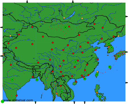
Climatic data of more than 3000 weather stations.
The available stations are represented by yellow and red dots on the map.
Hover mouse over dot to see the name of the station.
Then click to see the data.
To change the map : click on the green buttons with a black cross to zoom in, on the green button with a dash to zoom out, or on the green arrows for adjacent maps.