METAR-TAF
Airports :
Guadalajara
Acapulco
Aguascalientes
Ciudad Victoria
Colima
Cuernavaca
Durango
Guadalajara
Huatulco
León
Manzanillo
Mazatlán
Mexico City
Minatitlán
Morelia
Oaxaca
Poza Rica
Puebla
Puerto Escondido
Puerto Vallarta
Querétaro
San Luis Potosí
Tampico
Tepic
Toluca
Uruapan
Veracruz
Zacatecas
Zihuatanejo
Mexico, Southwest
Mexico
Mexico, East
Mexico, Northeast
Mexico, Northwest
Guadalajara International Airport Guadalajara, Mexico
latitude: 20-31N, longitude: 103-19W, elevation: 1528 m
Current weather observation The report was made 53 minutes ago, at 00:40 UTC
Wind 4 kt from the South/Southwest
Temperature 23 °C
Humidity 61 %
Pressure 1020 hPa
Visibility: 6.4 km
Broken clouds at a height of 2000 ft, Cumulonimbus. Broken clouds at a height of 8000 ft Overcast at a height of 30000 ft
METAR: MMGL 140040Z 20004KT 4SM BKN020CB BKN080 OVC300 23/15 A3013 RMK 8/363 HZY PCPN S/SW
Time: 20:33 (01:33 UTC) Forecast The report was made 2 hours and 33 minutes ago, at 23:00 UTC
Forecast valid from 14 at 00 UTC to 15 at 00 UTC
Wind 10 kt from the West/Southwest
Visibility: 8.0 km
Broken clouds at a height of 2000 ft, Cumulonimbus.
rain
Temporary
Wind 10 kt from the West/Northwest with gusts up to 20 kt
Visibility: 4.8 km
Broken clouds at a height of 1500 ft, Cumulonimbus.
thunderstorm, rain
From 14 at 0400 UTC
Wind 5 kt from the West/Southwest
Visibility: 8.0 km
Scattered clouds at a height of 2000 ft Broken clouds at a height of 8000 ft
haze
From 14 at 1600 UTC
Wind 5 kt from the North
Visibility: 10 km
Clear sky
From 14 at 2000 UTC
Wind 10 kt from the West/Southwest
Visibility: 10 km
Broken clouds at a height of 2000 ft, Cumulonimbus.
TAF: MMGL 132300Z 1400/1500 25010KT 5SM RA BKN020CB TX31/1421Z TN18/1412Z TEMPO 1400/1404 30010G20KT 3SM TSRA BKN015CB FM140400 25005KT 5SM HZ SCT020 BKN080 FM141600 36005KT P6SM SKC FM142000 25010KT P6SM BKN020CB
Weather observations and forecasts of more than 4000 airports (METAR and TAF reports).
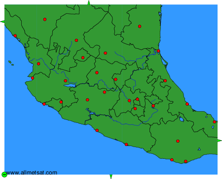
The available stations are represented by yellow and red dots on the map.
Hover mouse over dot to see the name of the station.
Then click to see weather observations and forecasts.
To change the map : click on the green buttons with a black cross to zoom in, on the green button with a dash to zoom out, or on the green arrows for adjacent maps.
