METAR-TAF
Airports :
Cap-Haïtien International Airport
Cap-Haïtien, Haiti
latitude: 19-43-59N, longitude: 72-11-41W, elevation: 3 m
Current weather observation
The report was made 2 hours and 23 minutes ago, at 23:00 UTC
Wind 11 kt from the Northeast
Temperature 30°C
Humidity 75%
Pressure 1013 hPa
Visibility: 9000 m
Few clouds at a height of 2400 ft, Cumulonimbus.
METAR: MTCH 012300Z 05011KT 9000 FEW024CB 30/25 Q1012 A2991 RMK:CB/SE/S
Time: 21:23 (01:23 UTC)
Forecast
The report was made 8 hours and 23 minutes ago, at 17:00 UTC
Forecast valid from 01 at 18 UTC to 02 at 18 UTC
Wind 11 kt from the North
Visibility: 9000 m
Few clouds at a height of 2600 ft
Becoming
from 01 at 20 UTC to 01 at 23 UTC
from 01 at 20 UTC to 01 at 23 UTC
Wind 14 kt from the East/Northeast
Few clouds at a height of 2800 ft, Towering cumulus.
From 02 at 0600 UTC
Wind 2 kt from variable directions
Visibility: 7000 m
Few clouds at a height of 1800 ft, Cumulonimbus.
Scattered clouds at a height of 20000 ft
Scattered clouds at a height of 20000 ft
TAF: MTCH 011700Z 0118/0218 01011KT 9000 FEW026 BECMG 0120/0123 07014KT FEW028TCU FM020600 VRB02KT 7000 FEW018CB SCT200
Weather observations and forecasts of more than 4000 airports (METAR and TAF reports).
The available stations are represented by yellow and red dots on the map.
Hover mouse over dot to see the name of the station.
Then click to see weather observations and forecasts.
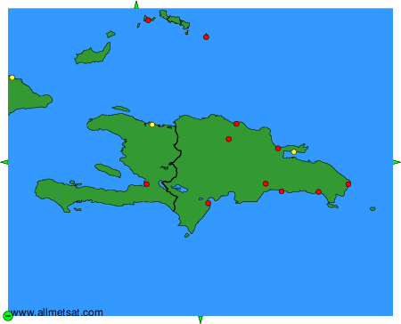
To change the map : click on the green buttons with a black cross to zoom in, on the green button with a dash to zoom out, or on the green arrows for adjacent maps.