METAR-TAF
Airports :
St. Petersburg-Clearwater
Apalachicola
Bartow
Boca Raton
Brooksville
Cape Canaveral
Clearwater
Cocoa Beach
Crestview
Cross City
Crystal River
Daytona Beach
DeLand
Destin
Duke Field
Fernandina Beach
Fort Lauderdale Executive
Fort Lauderdale-Hollywood
Fort Myers
Fort Myers Page
Fort Pierce
Gainesville
Hollywood
Homestead
Jacksonville-Cecil
Jacksonville-Craig
Jacksonville Intl.
Jacksonville-NAS
Kennedy Space Center
Key West
Kissimmee
Lake City
Lakeland
Leesburg
MacDill AFB
Marathon
Marianna
Mary Esther
Mayport
Melbourne
Miami
Miami Executive
Miami Opa Locka
Milton
Milton
Naples
NAS Key West
New Smyrna Beach
Ocala
Okeechobee
Orlando
Orlando-Executive
Orlando-Sanford
Ormond Beach
Panama City
Pensacola
Pensacola NAS
Perry
Plant City
Pompano Beach
Punta Gorda
Sarasota / Bradenton
Sebring
St. Augustine
St. Petersburg
St. Petersburg-Clearwater
Stuart
Tallahassee
Tampa
Tampa Intl.
The Villages
Titusville
Tyndall AFB
Valdosta
Valparaiso
Venice
Vero Beach
West Palm Beach
Winter Haven
Florida
Alabama
Cuba
Georgia
Jamaica
Louisiana
Mexico
Mississippi
North America
The Bahamas
St. Pete–Clearwater International Airport St. Petersburg-Clearwater, Florida, United States
latitude: 27-54-44N, longitude: 082-41-08W, elevation: 3 m
Current weather observation The report was made 56 minutes ago, at 13:53 UTC
Wind 8 kt from the North/Northeast
Temperature 26 °C
Humidity 74 %
Pressure 1014 hPa
Visibility: 16.1 km
Overcast at a height of 7000 ft
METAR: KPIE 141353Z 02008KT 10SM OVC070 26/21 A2993 RMK AO2 SLP135 T02610211 $
Time: 10:49 (14:49 UTC) Forecast The report was made 3 hours and 29 minutes ago, at 11:20 UTC
Forecast valid from 14 at 12 UTC to 15 at 12 UTC
Wind 6 kt from the North/Northeast
Visibility: 10 km
Scattered clouds at a height of 1500 ft Scattered clouds at a height of 5000 ft
From 14 at 1500 UTC
Wind 10 kt from the North/Northwest
Visibility: 10 km
Scattered clouds at a height of 5000 ft
From 14 at 2000 UTC
Wind 15 kt from the West/Northwest with gusts up to 22 kt
Visibility: 10 km
Few clouds at a height of 5000 ft
From 15 at 0100 UTC
Wind 8 kt from the Northwest
Visibility: 10 km
Clear sky
From 15 at 0300 UTC
Wind 5 kt from variable directions
Visibility: 10 km
TAF: KPIE 141120Z 1412/1512 02006KT P6SM SCT015 SCT050 FM141500 34010KT P6SM SCT050 FM142000 30015G22KT P6SM FEW050 FM150100 32008KT P6SM SKC FM150300 VRB05KT P6SM SKC
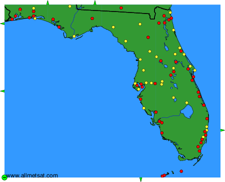
Weather observations and forecasts of more than 4000 airports (METAR and TAF reports).
The available stations are represented by yellow and red dots on the map.
Hover mouse over dot to see the name of the station.
Then click to see weather observations and forecasts.
To change the map : click on the green buttons with a black cross to zoom in, on the green button with a dash to zoom out, or on the green arrows for adjacent maps.
