METAR-TAF
Airports :
City of Derry Airport
Derry, Northern Ireland
latitude: 55-03N, longitude: 007-09W, elevation: 9 m
Current weather observation
The report was made 16 minutes ago, at 05:50 UTC
Wind 6 kt from the North/Northwest
Temperature 14°C
Humidity 94%
Pressure 1031 hPa
Visibility 10 km or more
Few clouds at a height of 1200 ft
Scattered clouds at a height of 4000 ft
Scattered clouds at a height of 4000 ft
METAR: EGAE 220550Z 33006KT 9999 FEW012 SCT040 14/13 Q1031
Time: 07:06 (06:06 UTC)
Forecast
The report was made 19 minutes ago, at 05:47 UTC
Forecast valid from 22 at 06 UTC to 22 at 15 UTC
Wind 8 kt from the North
Visibility 10 km or more
Few clouds at a height of 1200 ft
Temporary
from 22 at 10 UTC to 22 at 15 UTC
from 22 at 10 UTC to 22 at 15 UTC
Broken clouds at a height of 1200 ft
Probability 30%
from 22 at 12 UTC to 22 at 15 UTC
from 22 at 12 UTC to 22 at 15 UTC
Visibility: 5000 m
light drizzle,
TAF: EGAE 220547Z 2206/2215 35008KT 9999 FEW012 TEMPO 2210/2215 BKN012 PROB30 2212/2215 5000 -DZ
Weather observations and forecasts of more than 4000 airports (METAR and TAF reports).
The available stations are represented by yellow and red dots on the map.
Hover mouse over dot to see the name of the station.
Then click to see weather observations and forecasts.
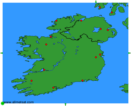
To change the map : click on the green buttons with a black cross to zoom in, on the green button with a dash to zoom out, or on the green arrows for adjacent maps.