METAR-TAF
Airports :
Kushiro Airport
Kushiro, Japan
latitude: 43-02N, longitude: 144-12E, elevation: 95 m
Current weather observation
METAR: RJCK 291000Z 20006KT 0200 R17/0300V0900N FG VV001 13/13 Q1013
Time: 20:08 (11:08 UTC)
Forecast
Broken clouds at a height of 1200 ft
from 29 at 06 UTC to 29 at 09 UTC
Broken clouds at a height of 500 ft
from 29 at 09 UTC to 29 at 12 UTC
Broken clouds at a height of 300 ft
from 29 at 12 UTC to 30 at 00 UTC
from 30 at 00 UTC to 30 at 06 UTC
Broken clouds at a height of 500 ft
from 30 at 06 UTC to 30 at 12 UTC
TAF: RJCK 290505Z 2906/3012 18006KT 9999 FEW005 BKN012 TEMPO 2906/2909 FEW003 BKN005 TEMPO 2909/2912 1500 BR FEW001 BKN003 TEMPO 2912/3000 0700 FG VV001 TEMPO 3000/3006 3000 BR FEW003 BKN005 TEMPO 3006/3012 0700 FG VV001
Weather observations and forecasts of more than 4000 airports (METAR and TAF reports).
The available stations are represented by yellow and red dots on the map.
Hover mouse over dot to see the name of the station.
Then click to see weather observations and forecasts.
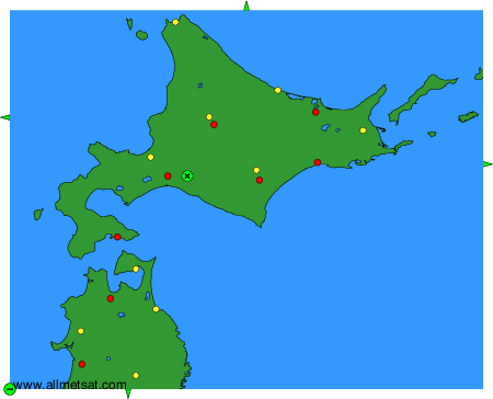
To change the map : click on the green buttons with a black cross to zoom in, on the green button with a dash to zoom out, or on the green arrows for adjacent maps.