METAR-TAF
Airports :
Sapporo
Akeno
Akita
Aomori
Asahikawa
Asahikawa Air Base
Chitose
Chofu
Fukuoka
Fukushima
Gifu
Hachinohe
Hagi
Hakodate
Hanamaki
Hiroshima
Hofu
Hyakuri
Iwakuni
Izumo
Kagoshima
Kanoya
Kansai
Kasumigaura
Kasuminome
Kisarazu
Kitakyushu
Kobe
Kochi
Komatsu
Komatsujima
Kumamoto
Kushiro
Matsumoto
Matsuyama
Memanbetsu
Miho-Yonago
Miyazaki
Monbetsu
Mutsu
Nagasaki
Nagoya
Nakashibetsu
Niigata
Nii Ōshima
Obihiro
Odate-Noshiro
Oita
Okayama
Osaka
Saga
Sapporo
Sendai
Seoul-Incheon
Shirahama
Shizuhama
Shizuoka
Shonai
Tachikawa
Tajima
Takamatsu
Tanegashima
Tateyama
Tokachi-Obihiro
Tokushima
Tokyo-Haneda
Tokyo Heliport
Tokyo Narita
Tottori
Toyama
Tsushima
Utsunomiya
Vladivostok
Wajima
Wakkanai
Yamagata
Yamaguchi Ube
Yao
Yokota
Japan
Asia
Central Siberia
China
Eastern Siberia
Japan, Hokkaido
Japan, Honshu
Japan, Kyushu Shikoku
Japan, Ryukyu Islands
Japan, Sapporo
Japan, Tokyo
North Korea
North Pacific
South Korea
Okadama Airport Sapporo, Japan
latitude: 43-07N, longitude: 141-23E, elevation: 8 m
Current weather observation The report was made 17 minutes ago, at 00:00 UTC
Wind 9 kt from the East/Southeast
Temperature 15 °C
Humidity 72 %
Pressure 1010 hPa
Visibility 10 km or more
Few clouds at a height of 2000 ft
METAR: RJCO 260000Z 12009KT 9999 FEW020 15/10 Q1010
Time: 09:17 (00:17 UTC) TAF: missing
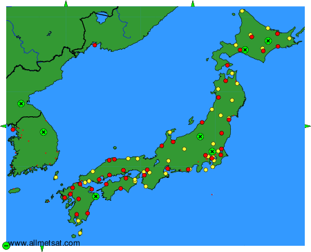
Weather observations and forecasts of more than 4000 airports (METAR and TAF reports).
The available stations are represented by yellow and red dots on the map.
Hover mouse over dot to see the name of the station.
Then click to see weather observations and forecasts.
To change the map : click on the green buttons with a black cross to zoom in, on the green button with a dash to zoom out, or on the green arrows for adjacent maps.