METAR-TAF
Airports :
Wabush
Akulivik
Amqui
Aupaluk
Bagotville
Baie-Comeau
Bancroft
Bangor
Bathurst
Beauceville
Beauport
Beaver Island
Berlin
Blanc-Sablon
Brevoort Island
Cap-Chat
Cap D Espoir
Cape Kakkiviak
Cape Kiglapait
Cap Madeleine
Cap Tourmente
Caribou
Caribou
Cartwright
Chamouchouane
Charlevoix
Charlo
Charlottetown
Chéticamp
Chibougamau
Churchill Falls
Chutes-des-Passes
Clayton Lake
Debert
Deer Lake
Deschambault-Grondines
Earlton
Eastmain
East Point
Englee
Ferolle Point
Franklin County
Fredericton
Frelighsburg
Frenchville
Gagetown
Gaspé
Gatineau
Goose Bay
Grand Étang
Greenville
Greenwood
Halifax
Hart Island
Havre-Saint-Pierre
Heath Point
High Falls
Hopedale
Houlton
Ile-aux-Grues
Ile Aux Perroquets
Ile Bicquette
Île d'Orléans
Ile Rouge
Inukjuak
Ivujivik
Jonquière
Kangiqsualujjuaq
Kangiqsujuaq
Kangirsuk
Kentville
Kimmirut
Kuujjuaq
Kuujjuarapik
La Baie
L Acadie
Lac-Jacques-Cartier
Lagoon City
La Grande-4
La Grande Rivière
La Pocatière
L'Assomption
La Tuque
Lennoxville
Longue-Pointe-de-Mingan
Lyndonville
Magdalen Islands
Makkovik
Malay Falls
Maniwaki
Massena
Matagami
McNabs Island
Millinocket
Mistook
Moncton
Mont-Joli
Montreal
Montreal-Mirabel
Montreal Trudeau
Mont-Tremblant
Morrisville
Muskoka
Nain
Natashquan
New Carlisle
Newport
Nicolet
Normandin
North Bay
North Cape
Onatchiway
Ottawa
Parent
Petawawa
Plattsburgh
Pointe Claveau
Pointe-des-Monts
Pointe-Noire
Point Lepreau
Port Hawkesbury
Port-Menier
Presque Isle
Puvirnituq
Quaqtaq
Quebec City
Resolution Island
Rivière Bonnard
Rivière-du-Loup
Roberval
Rocky Harbour
Rouyn-Noranda
Saglek Bay
Saint-Anicet
Sainte-Anne-de-Bellevue
Sainte-Clotilde-de-Châteauguay
Sainte-Foy
Saint-Hubert
Saint John
Saint-Léonard
Saint-Pierre
Salluit
Sanikiluaq
Schefferville
Sept-Îles
Shearwater
Sherbrooke
St. Anthony
Stephenville
St. Paul Island
St. Stephen
Summerside
Sydney
Tasiujaq
Trois-Rivières
Trois-Rivières
Tukialik Bay
Umiujaq
Valcartier
Val-d'Or
Varennes
Wabush
Waskaganish
Waterville
Wemindji
Quebec
Greenland
Maritimes
New England
New York
North America
Nunavut, Baffin Island, Ellesmere
Ontario, North
Ontario, South
Pennsylvania
Quebec, South
Wabush Airport Wabush, Newfoundland and Labrador, Canada
latitude: 52-56N, longitude: 066-52W, elevation: 551 m
Current weather observation The report was made 57 minutes ago, at 13:00 UTC
Wind 4 kt from the South
Temperature 17 °C
Humidity 100 %
Pressure 1015 hPa
Visibility: 16.1 km
Few clouds at a height of 600 ft Overcast at a height of 6000 ft
light rain showers
METAR: CYWK 021300Z 18004KT 10SM -SHRA FEW006 OVC060 17/17 A2996 RMK CU2SC6 SLP152 DENSITY ALT 2400FT
Time: 10:57 (13:57 UTC) Forecast The report was made 17 minutes ago, at 13:40 UTC
Forecast valid from 02 at 14 UTC to 03 at 02 UTC
Wind 5 kt from the South
Visibility: 10 km
Scattered clouds at a height of 1200 ft Overcast at a height of 5000 ft
Temporary
Visibility: 8.0 km
Broken clouds at a height of 1200 ft Overcast at a height of 5000 ft
light rain showers, mist
From 02 at 1700 UTC
Wind 8 kt from the South
Visibility: 10 km
Few clouds at a height of 1500 ft Broken clouds at a height of 3000 ft Overcast at a height of 10000 ft
light rain showers
Probability 30%
Wind 20 kt from variable directions with gusts up to 30 kt
Visibility: 3.2 km
Broken clouds at a height of 1500 ft Overcast at a height of 4000 ft, Cumulonimbus.
thunderstorm, rain, mist
From 03 at 0000 UTC
Wind 5 kt from the Southeast
Visibility: 10 km
Scattered clouds at a height of 1200 ft Overcast at a height of 2500 ft
light rain showers
Temporary
Visibility: 8.0 km
Broken clouds at a height of 1200 ft Overcast at a height of 2500 ft
light rain showers, mist
TAF: CYWK 021340Z 0214/0302 18005KT P6SM SCT012 OVC050 TEMPO 0214/0217 5SM -SHRA BR BKN012 OVC050 FM021700 18008KT P6SM -SHRA FEW015 BKN030 OVC100 PROB30 0217/0221 VRB20G30KT 2SM TSRA BR BKN015 OVC040CB FM030000 13005KT P6SM -SHRA SCT012 OVC025 TEMPO 0300/0302 5SM -SHRA BR BKN012 OVC025 RMK NXT FCST BY 022000Z
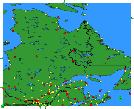
Weather observations and forecasts of more than 4000 airports (METAR and TAF reports).
The available stations are represented by yellow and red dots on the map.
Hover mouse over dot to see the name of the station.
Then click to see weather observations and forecasts.
To change the map : click on the green buttons with a black cross to zoom in, on the green button with a dash to zoom out, or on the green arrows for adjacent maps.