METAR-TAF
Airports :
Menominee
Aitkin
Albert Lea
Ames
Ankeny
Antigo
Appleton
Ashland
Aurora
Austin
Baraboo / Wisconsin Dells
Benton Harbor
Black River Falls
Boone
Boscobel
Buffalo
Burlington
Cambridge
Camp Douglas
Cedar Rapids
Chariton
Charles City
Chicago
Chicago-Midway
Clarion
Clinton
Clintonville
Cloquet
Cumberland
Davenport
Decorah
DeKalb
Des Moines
Dodge Center
Dubuque
Duluth
Duluth
Eagle River
Eau Claire
Elkhart
Escanaba
Eveleth
Fairfield
Faribault
Fond du Lac
Forest City
Frankfort
Freeport
Gary
Grand Rapids
Green Bay
Grinnell
Hancock
Hayward
Hibbing
Holland
Independence
Iowa City
Iron Mountain / Kingsford
Ironwood
Janesville
Joliet
Juneau
Kankakee
Kenosha
Knoxville
Lacon
La Crosse
Ladysmith
Land O' Lakes
Lansing
Lone Rock
Ludington
Madison
Manistee
Manistique
Manitowoc
Mankato
Maple Lake
Marquette
Marshalltown
Marshfield
Mason City
McGregor
Medford
Menominee
Menomonie
Merrill
Milwaukee
Milwaukee
Mineral Point
Minneapolis
Minneapolis / Blaine
Minneapolis / Crystal
Minneapolis / Eden Prairie
Minneapolis / Lakeville
Minocqua / Woodruff
Moline
Monroe
Monticello
Moose Lake
Mora
Morris
Mosinee
Munising
Muscatine
Muskegon
New Richmond
Newton
Oelwein
Osceola
Oshkosh
Ottumwa
Owatonna
Pella
Peru / LaSalle
Phillips
Platteville
Prairie du Chien
Preston
Princeton
Racine
Red Wing
Rhinelander
Rice Lake
Rochelle
Rochester
Rockford
Romeoville
Rush City
Saint Paul
Savanna
Shawano
Sheboygan
Silver Bay
Siren
South Bend
South Haven
South St. Paul
Sparta
Stanton
Sterling / Rock Falls
Stevens Point
Sturgeon Bay
Superior
Tomahawk
Two Harbors
Valparaiso
Vinton
Waseca
Washington
Waterloo
Watertown
Waukegan
Waukesha
Waupaca
Wausau
Webster City
West Bend
West Chicago
Wheeling / Prospect Heights
Winona
Wisconsin Rapids
Wisconsin
Illinois
Indiana
Iowa
Michigan
Minnesota
North America
Ohio
Ontario, North
Menominee-Marinette Twin County Airport Menominee, Michigan, United States
latitude: 45-08N, longitude: 087-38W, elevation: 626 ft
Current weather observation The report was made 47 minutes ago, at 18:57 UTC
Wind 7 mph from the East/Southeast
Temperature 72 °F
Humidity 60 %
Pressure 30.13 in. Hg
Visibility: 10 miles
Clear sky
METAR: KMNM 261857Z AUTO 12006KT 10SM CLR 22/14 A3013 RMK AO2 SLP203 T02220139 $
Time: 15:44 (19:44 UTC) TAF: missing
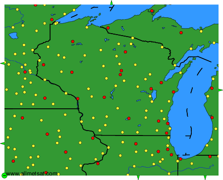
Weather observations and forecasts of more than 4000 airports (METAR and TAF reports).
The available stations are represented by yellow and red dots on the map.
Hover mouse over dot to see the name of the station.
Then click to see weather observations and forecasts.
To change the map : click on the green buttons with a black cross to zoom in, on the green button with a dash to zoom out, or on the green arrows for adjacent maps.