METAR-TAF
Airports :
Amsterdam
Algiers
Amman
Amsterdam
Ankara Esenboğa
Arkhangelsk
Athens
Baghdad
Bahrain
Bamako
Beirut
Belgrade
Berlin
Brussels
Bucharest
Budapest
Cairo
Copenhagen
Dakar
Damascus
Djibouti
Dubai
Dublin
Funchal
Geneva
Gibraltar
Gran Canaria
Helsinki
Istanbul Atatürk
Jeddah
Khartoum
Kuwait City
Larnaca
Lisbon
London-Heathrow
Longyearbyen
Luxembourg
Madrid
Moscow-Sheremetyevo
Murmansk
N'Djamena
Niamey
Nouakchott
Odessa
Oslo
Ouagadougou
Palma de Mallorca
Paris-Charles De Gaulle
Ponta Delgada
Prague
Rabat
Reykjavík
Riga
Rome-Fiumicino
Saint Petersburg
Sana'a
Sofia
Stockholm-Arlanda
Tehran
Tel Aviv
Tripoli
Tunis
Vienna
Volgograd
Warsaw
Zagreb
Europe
Africa
Albania
Algeria
Algeria, North
Arctic Ocean
Armenia
Asia
Austria
Azerbaijan
Azores
Bahrain
Belarus
Belgium
Bosnia and Herzegovina
Bulgaria
Burkina Faso
Canary Islands
Cape Verde
Central African Republic
Chad
Croatia
Cyprus
Czech Republic
Denmark
Djibouti
Egypt
England
Eritrea
Estonia
Ethiopia
Faroe Islands
Finland
France
Gambia
Georgia
Germany
Greece
Greenland
Guinea-Bissau
Hungary
Iceland
Indian Ocean
Iran
Iraq
Ireland
Israel
Italy
Italy, North
Jordan
Kuwait
Latvia
Lebanon
Libya
Lithuania
Luxembourg
Macedonia
Madeira
Mali
Mauritania
Moldova
Montenegro
Morocco
Netherlands
Niger
North Atlantic
North Sea
Norway
Oman
Palestine
Poland
Portugal
Qatar
Romania
Russia
Saudi Arabia
Scandinavia, Southwest
Scotland
Senegal
Serbia
Shetland
Slovakia
Slovenia
South Atlantic
Spain
Sudan
Sweden
Switzerland
Syria
Tunisia
Turkey
Ukraine
United Arab Emirates
United Kingdom
Wales
Yemen
Amsterdam Airport Schiphol Amsterdam, Netherlands
latitude: 52-18N, longitude: 004-46E, elevation: -4 m
Current weather observation The report was made 16 minutes ago, at 12:55 UTC
Wind 9 kt from the North/Northwest , varying between West/Northwest and Northeast
Temperature 10 °C
Humidity 57 %
Pressure 998 hPa
Visibility 10 km or more
Few clouds at a height of 2300 ft, Cumulonimbus. Scattered clouds at a height of 3500 ft
light rain showers
METAR: EHAM 141255Z 33009KT 290V050 9999 -SHRA FEW023CB SCT035 10/02 Q0998 BECMG NSW
Time: 15:11 (13:11 UTC) Forecast The report was made 1 hour and 58 minutes ago, at 11:13 UTC
Forecast valid from 14 at 12 UTC to 15 at 18 UTC
Wind 13 kt from the North
Visibility 10 km or more
Scattered clouds at a height of 3000 ft
Probability 40% :
Temporary
Visibility: 6000 m
Scattered clouds at a height of 2500 ft, Cumulonimbus. Broken clouds at a height of 3000 ft
rain showers
Becoming
Wind 3 kt from the West
Probability 40% :
Temporary
Visibility: 6000 m
Scattered clouds at a height of 2200 ft, Cumulonimbus. Broken clouds at a height of 3000 ft
rain showers
Becoming
Wind 14 kt from the West/Northwest
Temporary
Visibility: 7000 m
Scattered clouds at a height of 1800 ft, Towering cumulus. Broken clouds at a height of 2500 ft
light rain showers, light rain
TAF: EHAM 141113Z 1412/1518 35013KT 9999 SCT030 PROB40 TEMPO 1412/1416 6000 SHRA SCT025CB BKN030 BECMG 1417/1420 27003KT PROB40 TEMPO 1504/1513 6000 SHRA SCT022CB BKN030 BECMG 1508/1511 30014KT TEMPO 1513/1518 7000 -SHRA -RA SCT018TCU BKN025
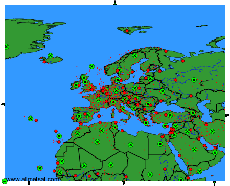
Weather observations and forecasts of more than 4000 airports (METAR and TAF reports).
The available stations are represented by yellow and red dots on the map.
Hover mouse over dot to see the name of the station.
Then click to see weather observations and forecasts.
To change the map : click on the green buttons with a black cross to zoom in, on the green button with a dash to zoom out, or on the green arrows for adjacent maps.
