METAR-TAF
Airports :
Rovaniemi
Aalborg
Aarhus
Ålesund
Alta
Ämari
Andøya
Arvidsjaur
Bardufoss
Båtsfjord
Bergen
Berlevåg
Billund
Bodø
Borlänge
Brønnøysund
Copenhagen
Draugen
Enontekiö
Esbjerg
Evenes
Florø
Førde
Gällivare
Gamvik
Gothenburg
Gothenburg-Landvetter
Halmstad
Hammerfest
Hasvik
Haugesund
Heidrun
Helsingborg
Helsinki
Helsinki
Hemavan
Honningsvåg
Ivalo
Jämsä
Joensuu
Jönköping
Jyväskylä
Kajaani
Kalmar
Kärdla
Karlstad
Karup
Kemi
Kirkenes
Kiruna
Kittilä
Kokkola
Kolding
Kramfors
Kristiansand
Kristianstad
Kristiansund
Kuopio
Kuressaare
Kuusamo
Lakselv
Lappeenranta
Leknes
Liepāja
Linköping
Linköping
Ljungbyhed
Longyearbyen
Luleå
Lycksele
Malmö
Mariehamn
Mikkeli
Mo I Rana
Molde
Mora
Mosjøen
Murmansk
Namsos
Narvik
Norne Fpso
Norrköping
Notodden
Odense
Örebro
Ørland
Örnsköldsvik
Ørsta-Volda
Oslo
Östersund-Frösön
Oulu
Pajala
Palanga
Pärnu
Pori
Pskov
Riga
Ringkøbing-Skjern
Rønne
Ronneby
Røros
Rørvik
Roskilde
Røst
Rovaniemi
Rygge
Saint Petersburg
Sälen Trysil
Sandane
Sandefjord
Sandnessjøen
Såtenäs
Savonlinna
Seinäjoki-Ilmajoki
Šiauliai
Sindal
Skellefteå
Skövde
Sogndal
Sørkjosen
Stavanger
Stockholm
Stockholm-Arlanda
Stockholm-Skavsta
Stokmarknes
Stord
Storuman
Sundsvall-Härnösand
Sveg
Svolvær
Tallinn
Tampere
Tartu
Torsby
Trollhättan-Vänersborg
Tromsø
Trondheim
Turku
Umeå
Uppsala
Utti
Vaasa
Vadsø
Værøy
Vardø
Västerås
Växjö
Ventspils
Vidsel
Vilhelmina
Visby
Vitebsk
Vojens
Norway, Sweden, Finland
Arctic Ocean
Belarus
Denmark
Estonia
Europe
Faroe Islands
Germany
Latvia
Lithuania
Moldova
North Sea
Poland
Russia
Scandinavia, Southwest
Shetland
Ukraine
United Kingdom
Rovaniemi Airport Rovaniemi, Finland
latitude: 66-34N, longitude: 025-50E, elevation: 197 m
Current weather observation The report was made 9 minutes ago, at 07:20 UTC
Wind 9 kt from the South/Southwest
Temperature -8 °C
Humidity 92 %
Pressure 1005 hPa
Visibility: 0600 m
Overcast at a height of 100 ft
light snow showers
METAR: EFRO 260720Z AUTO 21009KT 0600 R21/P2000D -SHSN OVC001 M08/M09 Q1005
Time: 09:29 (07:29 UTC) Forecast The report was made 2 hours and 1 minutes ago, at 05:28 UTC
Forecast valid from 26 at 06 UTC to 27 at 06 UTC
Wind 6 kt from the South/Southeast
Visibility: 8000 m
Broken clouds at a height of 300 ft
light snow
Temporary from 26 at 06 UTC to 26 at 09 UTC
Visibility: 1200 m
Broken clouds at a height of 100 ft
mist
Temporary from 26 at 09 UTC to 26 at 13 UTC
Visibility: 2000 m
Scattered clouds at a height of 200 ft
patches of fog
Becoming from 26 at 13 UTC to 26 at 15 UTC
Wind 10 kt from the Southwest
Temporary from 26 at 13 UTC to 26 at 16 UTC
Visibility: 3000 m
Broken clouds at a height of 500 ft
(light) freezing, drizzle, snow
Becoming from 26 at 16 UTC to 26 at 17 UTC
Visibility 10 km or more
no clouds below 1500 m and no cumulonimbus
Becoming from 27 at 00 UTC to 27 at 02 UTC
Wind 6 kt from the South/Southeast
Visibility: 0500 m
at a height of 100 ft
freezing fog
Becoming from 27 at 02 UTC to 27 at 04 UTC
Visibility 10 km or more
Few clouds at a height of 200 ft
Becoming from 27 at 04 UTC to 27 at 06 UTC
Wind 15 kt from the South with gusts up to 25 kt
Broken clouds at a height of 700 ft
TAF: EFRO 260528Z 2606/2706 16006KT 8000 -SN BKN003 TEMPO 2606/2609 1200 BR BKN001 TEMPO 2609/2613 2000 BCFG SCT002 BECMG 2613/2615 23010KT TEMPO 2613/2616 3000 -FZDZSN BKN005 BECMG 2616/2617 CAVOK BECMG 2700/2702 16006KT 0500 FZFG VV001 BECMG 2702/2704 9999 NSW FEW002 BECMG 2704/2706 19015G25KT BKN007
Weather observations and forecasts of more than 4000 airports (METAR and TAF reports).
The available stations are represented by yellow and red dots on the map.
Hover mouse over dot to see the name of the station.
Then click to see weather observations and forecasts.
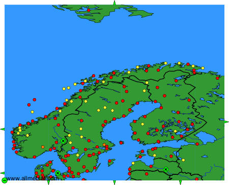
To change the map : click on the green buttons with a black cross to zoom in, on the green button with a dash to zoom out, or on the green arrows for adjacent maps.