METAR-TAF
Airports :
Aalborg
Aalborg
Aarhus
Ålesund
Arvidsjaur
Bergen
Billund
Borlänge
Brønnøysund
Copenhagen
Draugen
Esbjerg
F16-a
F3-fb-1
Florø
Førde
Gdańsk
Glücksburg
Gothenburg
Gothenburg-Landvetter
Halmstad
Haugesund
Heidrun
Helsingborg
Hemavan
Hohn
Jönköping
Kalmar
Karlstad
Karup
Kiel
Kolding
Kramfors
Kristiansand
Kristianstad
Kristiansund
Linköping
Linköping
Ljungbyhed
Lycksele
Malmö
Mariehamn
Mo I Rana
Molde
Mora
Mosjøen
Namsos
Norne Fpso
Norrköping
Notodden
Odense
Örebro
Ørland
Örnsköldsvik
Ørsta-Volda
Oslo
Östersund-Frösön
Ringkøbing-Skjern
Rønne
Ronneby
Røros
Rørvik
Roskilde
Rygge
Sälen Trysil
Sandane
Sandefjord
Sandnessjøen
Såtenäs
Schleswig-Jagel
Sindal
Skövde
Sogndal
Sønderborg
Stavanger
Stockholm
Stockholm-Arlanda
Stockholm-Skavsta
Stord
Storuman
Sundsvall-Härnösand
Sveg
Torsby
Trollhättan-Vänersborg
Trondheim
Uppsala
Västerås
Växjö
Vilhelmina
Visby
Vojens
Westerland
Scandinavia, Southwest
Denmark
Estonia
Europe
Faroe Islands
Finland
Germany
Latvia
Lithuania
North Sea
Norway
Poland
Shetland
Sweden
United Kingdom
Aalborg Airport Aalborg, Denmark
latitude: 57-06N, longitude: 009-51E, elevation: 3 m
Current weather observation The report was made 10 minutes ago, at 11:50 UTC
Wind 9 kt from the Southeast
Temperature 2 °C
Humidity 93 %
Pressure 1006 hPa
Visibility: 2100 m
mist
METAR: EKYT 131150Z AUTO 13009KT 2100 BR OVC003/// 02/01 Q1006
Time: 13:00 (12:00 UTC) Forecast The report was made 33 minutes ago, at 11:27 UTC
Forecast valid from 13 at 12 UTC to 14 at 12 UTC
Wind 12 kt from the Southeast
Visibility: 0500 m
Broken clouds at a height of 200 ft
fog
Temporary from 13 at 12 UTC to 13 at 20 UTC
Visibility: 3000 m
Broken clouds at a height of 400 ft
mist
Becoming from 13 at 20 UTC to 13 at 22 UTC
Visibility: 2500 m
Broken clouds at a height of 400 ft
rain, drizzle
Temporary from 13 at 22 UTC to 14 at 06 UTC
Wind 12 kt from the South with gusts up to 22 kt
Visibility: 5000 m
Broken clouds at a height of 800 ft
light rain
Becoming from 14 at 06 UTC to 14 at 08 UTC
Wind 12 kt from the West/Southwest
Visibility 10 km or more
Few clouds at a height of 500 ft Broken clouds at a height of 3000 ft
TAF: EKYT 131127Z 1312/1412 14012KT 0500 FG BKN002 TEMPO 1312/1320 3000 BR BKN004 BECMG 1320/1322 2500 RADZ BKN004 TEMPO 1322/1406 18012G22KT 5000 -RA BKN008 BECMG 1406/1408 24012KT 9999 NSW FEW005 BKN030
Weather observations and forecasts of more than 4000 airports (METAR and TAF reports).
The available stations are represented by yellow and red dots on the map.
Hover mouse over dot to see the name of the station.
Then click to see weather observations and forecasts.
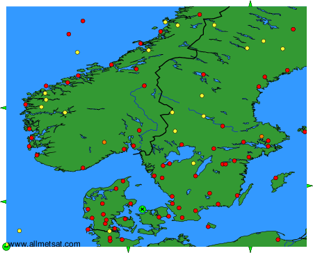
To change the map : click on the green buttons with a black cross to zoom in, on the green button with a dash to zoom out, or on the green arrows for adjacent maps.